Skip to content
  • Centre County Skywarn – Facebook

Stormstown Dispatch

Musings on Weather, Climate and Life in Central Pennsylvania

Upper Air

Extended Winter Weather

March 16, 2018March 16, 2018BillLeave a comment

gfs_namer_000_300_wnd_ht

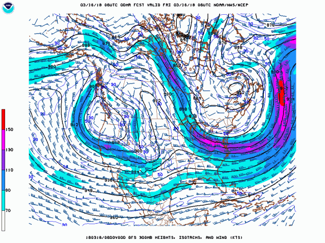
The above is today’s upper level 300 mb chart. The 300 mb level, about 30,000 ft (9100 m) is where one would typically find the jet streams. The polar jet stream is clearly shown in the upper left portion of the chart. Arctic air has been dominating the northeastern US and is a reason for why the cold weather has been persisting this month.

Data, MeteorologyJet Stream, Upper Air
Blogs I Follow
  • Chris Martz
  • Lifehacker
  • No Tricks Zone
  • Roy Spencer, PhD
  • Watts Up With That
Follow Stormstown Dispatch on WordPress.com
Latest Posts
  • Summary of Autumn 2025
  • November 2025 Weather Summary
  • Summary of the 2025 Atlantic Hurricane Season
  • October 2025 Weather Summary
  • 2025 Drought
Blog at WordPress.com.
  • Subscribe Subscribed
    • Stormstown Dispatch
    • Join 39 other subscribers
    • Already have a WordPress.com account? Log in now.
    • Stormstown Dispatch
    • Subscribe Subscribed
    • Sign up
    • Log in
    • Report this content
    • View site in Reader
    • Manage subscriptions
    • Collapse this bar
 

Loading Comments...