                            2016 ANNUAL CLIMATOLOGICAL SUMMARY

CITY: Stormstown   STATE: PA
ELEV:  1385 ft  LAT: 40.8  LONG: 77.87

               TEMPERATURE (°F), HEAT BASE 65.0, COOL BASE 65.0
                          DEP.  HEAT  COOL
        MEAN  MEAN        FROM  DEG   DEG                        MAX  MAX  MIN
 YR MO  MAX   MIN   MEAN  NORM  DAYS  DAYS  HI  DATE  LOW  DATE  >=90 <=32 <=32
--------------------------------------------------------------------------------
 16  1  34.3  17.3  25.9   1.3  1211     0  59.4  31   5.0    5    0   12   30
 16  2  40.0  23.1  31.9   5.1   960     0  65.9  28   0.5   12    0    7   22
 16  3  56.6  33.6  45.3   8.8   618     8  76.2   9  16.0    3    0    0   14
 16  4  59.6  35.7  48.4   0.7   522    23  80.9  18  19.3    6    0    0   10
 16  5  68.8  48.4  58.5  -0.1   273    71  88.6  28  36.6   19    0    0    0
 16  6  79.1  56.5  68.2   0.9    70   166  87.7  11  43.2   10    0    0    0
 16  7  86.2  62.0  73.6   2.4    28   295  95.7  25  49.6    3    9    0    0
 16  8  85.3  62.7  73.2   3.6    24   278  92.7  12  50.8   23    3    0    0
 16  9  76.9  53.9  65.1   2.9   127   131  89.0  10  39.8   25    0    0    0
 16 10  63.9  43.4  53.2   2.1   388    22  79.6  18  28.4   26    0    0    3
 16 11  54.1  34.3  43.9   3.1   636     2  73.6   2  23.2   23    0    0   13
 16 12  37.6  24.6  31.2   1.4  1047     0  52.1  27   5.9   16    0    7   24
--------------------------------------------------------------------------------
        61.9  41.4  51.6   2.7  5905   997  95.7 JUL   0.5  FEB   12   26  116

                                PRECIPITATION (in)

               DEP.   MAX        DAYS OF RAIN
               FROM   OBS.          OVER
 YR MO  TOTAL  NORM   DAY  DATE .01   .1   1
---------------------------------------------
 16  1  1.58  -0.92  1.12   10    7    2    1
 16  2  2.99   0.29  1.23    3    9    3    1
 16  3  1.92  -1.38  0.55   13   10    6    0
 16  4  1.85  -1.15  0.50   28   12    5    0
 16  5  3.52  -0.28  0.73   21   17   10    0
 16  6  2.12  -2.08  0.60    5   11    8    0
 16  7  1.16  -2.64  0.26   30    8    7    0
 16  8  5.61   2.31  3.47   10   11    8    1
 16  9  3.49   0.09  1.41   29   10    7    1
 16 10  6.95   4.05  3.62   20   13    7    2
 16 11  1.22  -2.18  0.62   30    5    3    0
 16 12  2.07  -0.73  0.76   18   12    4    0
---------------------------------------------
       34.48 -4.62  3.62  OCT  125   70    6

                                WIND SPEED (mph)
                          DOM
 YR MO   AVG.  HI   DATE  DIR
---------------------------------
 16  1   4.7  42.0   10     W
 16  2   4.5  38.0   25    SW
 16  3   4.1  54.0   28    SE
 16  4   4.0  43.0    3    NW
 16  5   2.7  34.0    8    SW
 16  6   2.9  34.0   12    SW
 16  7   2.5  26.0   15    SW
 16  8   2.2  35.0   16     S
 16  9   2.1  24.0    8    NE
 16 10   2.9  49.0   20   WNW
 16 11   3.9  41.0   20     W
 16 12   5.4  34.0   12     W
---------------------------------
         3.5  54.0  MAR    W
Meteorology
Pyranometer
Today, I installed a new weather instrument, for 2017 and beyond, to my personal weather station (PWS). I installed a pyranometer to measure the solar radiation flux density (W/m**2). The data from the instrument will be sampled every 30 minutes, along with the other parameters that are already being logged.
I have been told that the State College region is cloudier than most. Now I can measure just how “gray” the environment is here.
Indian Summer
Some would say that our area is now in the midst of Indian Summer (is that politically correct?). Yesterday morning, the temperature in Stormstown fell just below 32 deg F (31.6 F at 6:00 AM EDT), the first recorded freezing temperature of the season. There was frost on the lawns as seen below:

As the sun rose, the frost that was in full sunlight dissipated, while the frost in shadow remained.
The foliage has some color. However, it is not expected to be spectacular this year as the region has suffered a drought over the summer.
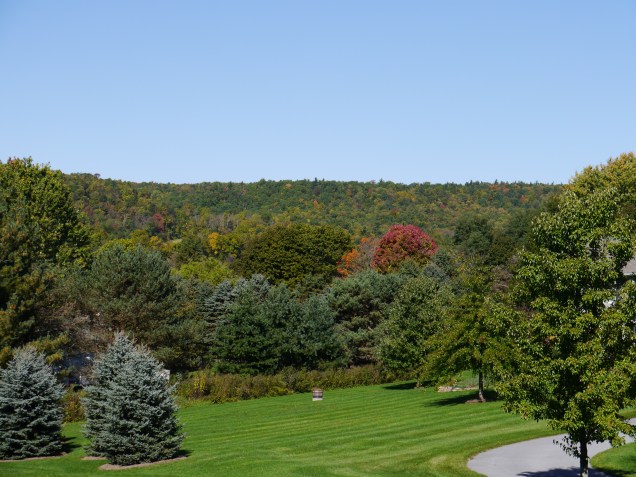
It is definitely jacket weather here, nonetheless.
Tropical Storm Matthew
Tropical Storm Matthew formed today. It is forecast to become a hurricane this Friday.
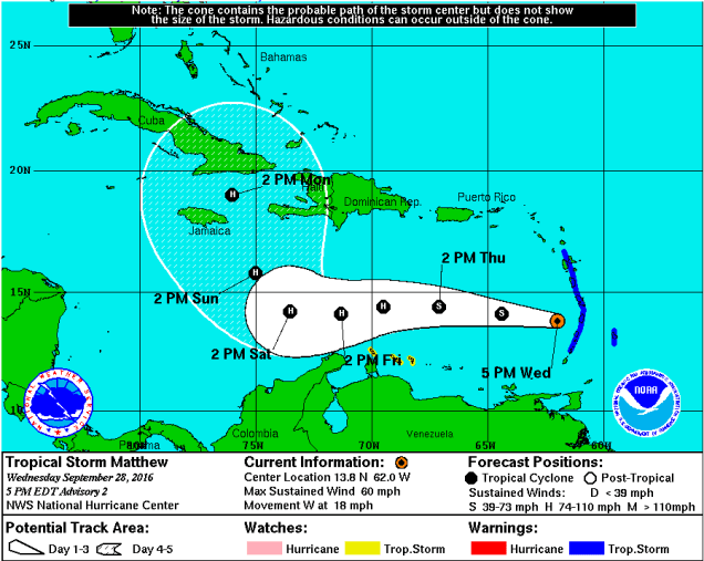
What is unusual is that the forecast track has the system making a hard right turn to the north sometime this weekend. Most of the models are in agreement to that forecast.
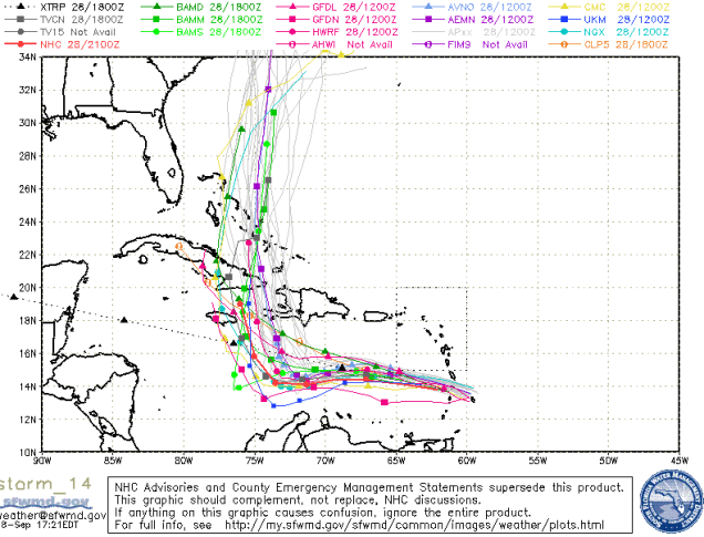
However, the two main models, GFS and ECMWF, disagree on where it will track a week from now. An earlier run of the GFS had it going up Chesapeake Bay next Thursday. The ECMWF has it moving slower with a possible landfall in southern Florida, so this should be watched carefully in the coming days.
BloomSky Weather Station
Over the weekend, I installed a BloomSky weather station at my home in Stormstown. The installation was simple. The only tool required was a Phillips screwdriver.
First, the mount was simply clamped to the backyard fence. Then a mounting plate for the solar panel was screwed onto the mount. The solar panel simply clipped to the plate. Before mounting the sensors, it had to be configured for the WiFi by using the iOS app. This was an easy process after plugging it in using the supplied AC adapter.
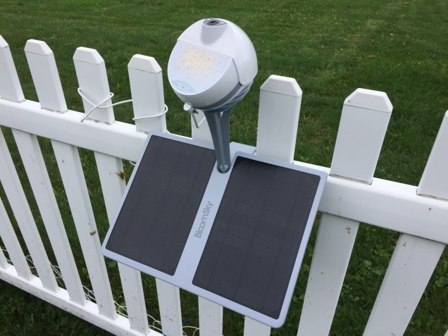
Lastly, the weather station itself only had to be dropped in place into the mount, and then plug in the solar panel. The only issue was the the air pressure didn’t report at first. This was resolved by unplugging the solar array and cycling the power from the internal battery. Then plug the solar array back in.
Data and camera imagery are located here:
https://www.wunderground.com/personal-weather-station/dashboard?ID=KPAPORTM15#history
Cloud Seeding Using Drones
While reading the latest issue of Weatherwise, I learned that The Desert Research Institute of Nevada has been conducting experiments using a drone for cloud seeding.
https://www.engadget.com/2016/05/04/cloud-seeding-drone-makes-first-flight-over-nevada/
This is surprising considering that many cloud seeding experimental programs were suspended following The Rapid City Flood in June 1972. Cloud seeding was being conducted nearby at the time.
http://www.weathermodification.org/publications/index.php/JWM/article/viewFile/166/212
Weather modification is a double edge sword and results have been dubious at best. In 1972, there were lawsuits against those that were conducting cloud seeding near Rapid City, even though there was little evidence that cloud seeding had augmented the rainfall that caused the flooding.
Penn State had also been conducting similar experiments in the seventies with their own aircraft. That program was also suspended. The plane that was being used for weather modification was refitted for air pollution studies.
Gaston and Invest 99L
Tropical Storm Gaston developed today. However, unless you’re shipping something across the Atlantic, that’s all you need to know. It is forecast to recurve and remain at sea.
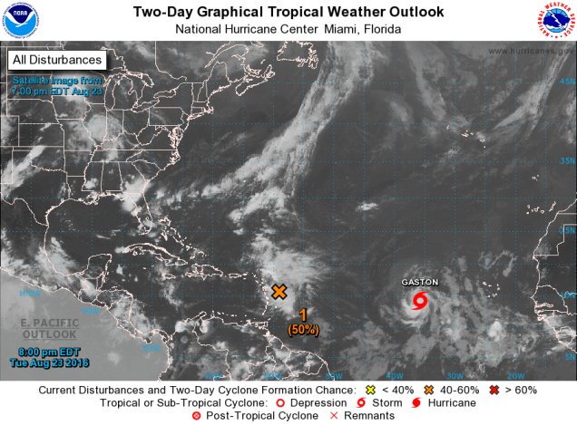
The focus is still on Invest 99L. Now the ECMWF model is bullish on possible US landfall in The Gulf of Mexico around the Florida panhandle next Tuesday. The GFS model, not so much. Still too far out for any reasonable certainty.
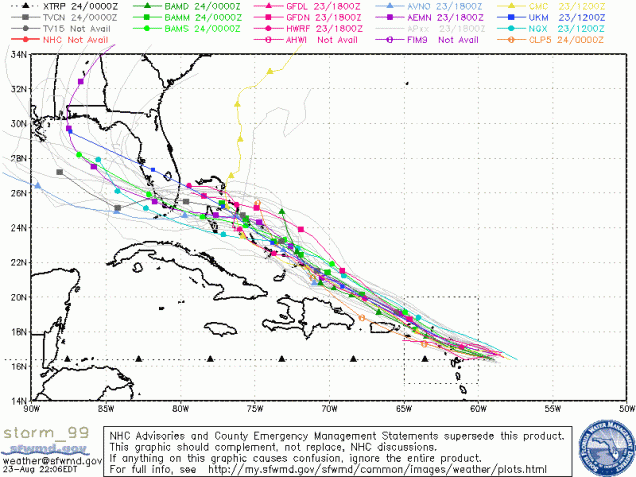
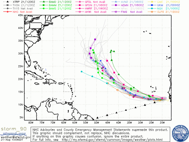
Invest 90 and 99
As stated in a previous post, the forecasts can significantly change for systems that are forecast many days in advance. The 06 UTC GFS model run is not so bullish on Invest 99. The GFS now shows the storm making a hard right out to sea as it moves near The Bahamas.

Focus is also on Invest 90 which is ow developing off the west coast of Africa. The models, as of this writing, indicate that it will not be a threat to the US.
The Tropics Awakens
The latest 12 UTC GFS model run is featuring two systems that may affect US interests by next week. What does persist is the system that is tracking into The Gulf of Mexico. The other system, more intense as depicted by the model, recurves before impacting the east coast. Both systems should be watched closely in the coming days.
Proto Gaston
The following image looks innocuous, but it has the potential to develop into a major Atlantic tropical system within the next week or so.
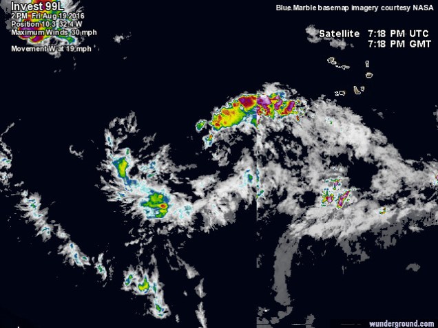
The models, as of this afternoon, have the storm tracking near Florida and/or into The Gulf of Mexico. However, this is still many days away and the forecast can change.

The GFS model is especially bullish, as seen in the video below.

