Forgotten Technology: The Sling Psychrometer

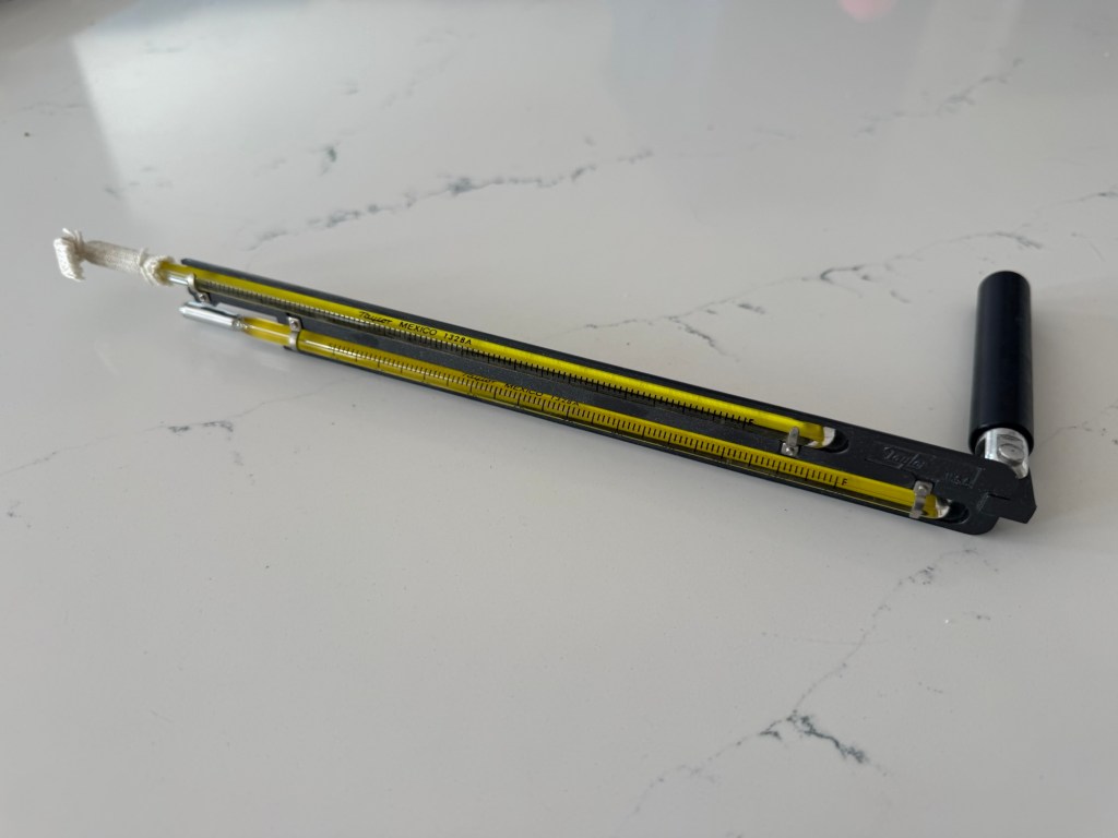
My personal sling psychrometer obtained in the mid 1970s.

Before electronic hygrometers became widely available, one of the primary instruments used to measure atmospheric humidity was the sling psychrometer.

James Hutton was the first to discover that a thermometer moistened by water will show a cooler temperature than a dry thermometer when exposed to the wind. Psychrometric equations were later developed and refined during the 19th Century.

The sling psychometer consists of two thermometers mounted side by side on a frame. One thermometer is kept dry and measures the ambient air temperature; this is known as the dry-bulb thermometer. The other thermometer has its bulb wrapped in a cotton wick that is saturated with distilled water. This is the wet-bulb thermometer.

The frame is attached to a handle with a swivel joint, allowing the thermometers to be rapidly swung through the air. As air passes over the wet wick, evaporation occurs, causing the temperature of the wet-bulb thermometer to decrease. The amount of cooling depends on the moisture content of the air. Drier air promotes more evaporation and produces a larger temperature difference between the wet-bulb and dry-bulb readings, while humid air results in less cooling.

After the instrument has been spun for a sufficient period, the wet-bulb and dry-bulb temperatures are quickly recorded. Using psychrometric tables or charts, these readings can then be used to determine the relative humidity, absolute humidity, or dew point temperature.
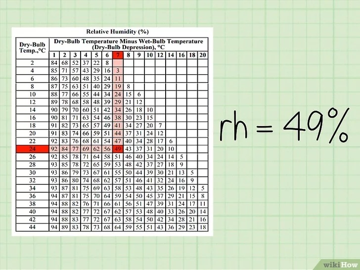
Although modern electronic sensors have largely replaced sling psychrometers, the instrument remains an important teaching tool and a reliable reference standard for humidity measurements.
Forgotten Technology: The Campbell-Stokes Sunshine Recorder

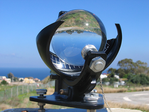
Before electronic and digital sunshine sensors became available, daily sunshine duration was measured using the Campbell–Stokes sunshine recorder.

The first sunshine recorder was invented by John Francis Campbell in 1853 and later refined by George Gabriel Stokes in 1879. Campbell’s original design used a water-filled glass sphere that focused the Sun’s rays onto a wooden surface. The instrument was carefully aligned for the local latitude and the ecliptic so that the time scale corresponded with solar time. The water-filled sphere was later replaced with a solid glass sphere, but the repeated scorch marks on the wooden surface made the original design impractical.

To improve the instrument, a specially designed photosensitive card was introduced. The glass sphere concentrated the Sun’s rays onto the card, burning a hole when the sunlight was sufficiently intense and leaving only a scorch mark under weaker conditions. As the Sun moved across the sky, the burn or scorch trace progressed across the card, creating a record of the day’s sunshine. At the end of the day, the card was removed and examined. The length of the burn trace was measured to determine the duration of bright sunshine, while the appearance of the marks provided a rough indication of solar intensity.

Although the Campbell–Stokes recorder was a significant advance for its time and served as the international standard for many decades, it had several limitations. The Sun’s rays at sunrise and sunset were often too weak to burn the card, causing sunshine during those periods to go unrecorded. Intermittent sunshine produced broken or faint burn traces that required subjective interpretation, leading to inconsistencies between observers. In addition, rain could damage the recording card, while frost, ice, snow, or condensation on the glass sphere could reduce its ability to focus sunlight accurately, resulting in measurement errors.

July 2026 Weather Summary

July was 0.5 deg F above normal for temperature. The first 4 days of July had highs exceeding 90 F. The high for the month was 95.1 deg. F recorded on July 2. The low for the month was 46.5 deg F, recorded on July 23. There were 26 heating degree days and 265 cooling degree days.

July was an above-normal month for precipitation with 7.12 inches of rainfall recorded, which was 3.33 inches above normal. The maximum rainfall in a single day was 2.45 inches, recorded on July 6. There were 9 days of rain >.01 in, 7 >.10 in, and 3 >1 in.

High wind speed of 29 mph on July 4.

July 2026 Data

From July 15 to July 19, smoke from wildfires in Ontario, Canada, and northern Minnesota affected our area. The chart below shows the air quality index (AQI) and the particulate density for 1, 2.5, and 10 microns.

June 2026 Weather Summary

June was 0.2 deg F below normal for temperature. The high for the month was 91 deg. F was recorded on June 11. The low for the month was 42 deg F, recorded on June 2. There were 75 heating degree days and 162 cooling degree days. There was 1 day that was greater than or equal to 90 deg F.

June was an above-normal month for precipitation with 4.65 inches of rainfall recorded, which was 0.56 inches above normal. The maximum rainfall in a single day was 1.43 inches, recorded on June 14. There were 15 days of rain >.01 in, 10 >.10 in, and 1 > 1 in.

High wind speed of 35 mph on June 11.

June 2026 Data

Summary of Spring 2026

Meteorological Spring is officially over. Here is a brief summary of March 1 – May 31, 2026, in Stormstown, PA:

Number of Days Max T <= 32 F: 1
Number of Days Min T <= 32 F: 22
Max T: 90.8 F – May 18, 2026
Min T: 10.7 F – March 18, 2026

Mar Dep from Normal: 7.5 F
Apr Dep from Normal: 5.0 F
May Dep from Normal: -2.1 F

Heating Degree Days: 1320
Cooling Degree Days: 136

Mar Precip: 4.82″, 1.44″ above normal
Apr Precip: 4.45, 0.94″ above normal
May Precip: 4.21″, 0.57″ above normal

May 2026 Weather Summary

May was 2.1 deg F below normal for temperature. The high for the month was 90.8 F, recorded on May 18. The low for the month was 29.4 F, recorded on May 1. There were 2 days at or below 32 F and 1 day at or greater than 90 F. The last freeze of the season was on May 12. There were 293 heating degree days and 69 cooling degree days.

May was an above-normal month for precipitation with 4.21 inches of rainfall recorded, which was 0.57 inches above normal. The maximum rainfall in a single day was 1.09 inches, recorded on May 23. There were 17 days of rain >.01 in, 13 >.10 in, and 1 > 1 in.

The high wind speed for the month was 38 mph on May 7.

May 2026 Data

April 2026 Weather Summary

April was 5.0 F above normal for temperature. The high for the month was 85.0 F, recorded on April 16. The low for the month was 19.7 F, recorded on April 8. There were 4 days at or below 32 F. There were 372 heating degree days and 51 cooling degree days.

April was an above-normal month for precipitation with 4.45 inches of rainfall recorded, which was 0.94 inches above normal. The maximum rainfall in a single day was 0.80 inches, recorded on April 25. There were 18 days of rain >.01 in, 6 >.10 in, and 0 > 1 in.

High wind speed of 49 mph on April 29.

April 2026 Data

As of April 30, the total annual rainfall, 12.48″, was above normal for the year so far.

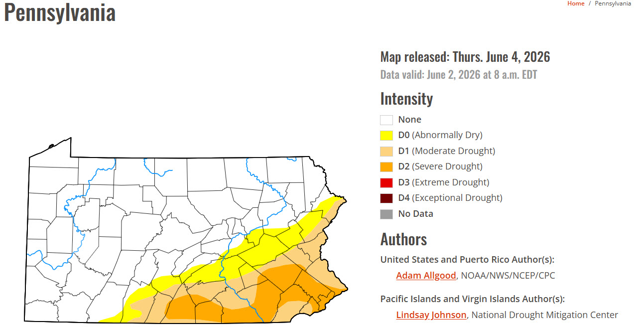
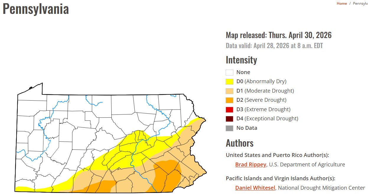
Drought update.

March 2026 Weather Summary

March was 7.4 deg F above normal for temperature. The high for the month was 82.9 deg. F, recorded on March 22. The low for the month was 10.7 deg F, recorded on March 18. There was 1 day where the maximum temperature was at or below 32 F, and there were 16 days where the minimum temperature was at or below 32 F. There were 665 heating degree days and 16 cooling degree days.

March was an above-normal month for precipitation, with 4.82 inches of rainfall recorded, 1.44 inches above normal. The maximum rainfall in a single day was 0.87 inches, recorded on March 5. There were 14 days of rain >.01 in, 10 >.10 in, and 0 > 1 in. There was 2.4″ of snow accumulation.

The highest recorded wind speed was 47 mph on March 13.

March 2026 Data

Summary of Winter 2025-2026

Meteorological Winter is officially over. Here is a brief summary of December 1, 2025-February 28, 2026, in Stormstown, PA:

Number of Days Max T <= 32 F: 37 

Number of Days Min T <= 32 F: 83

Number of Days Min T <= 0 F: 4  

Max T: 63.3 F – February 28, 2026 

Min T: -4.6 F – February 8, 2026

Dec Dep from Normal: -3.8 F  

Jan Dep from Normal: -3.7 F  

Feb Dep from Normal: -0.1 F  

Heating Degree Days: 3421

Cooling Degree Days: 0 

Dec Precip: 1.92″, 1.26″ below normal  

Jan Precip: 2.29″, 0.63″ below normal  

Feb Precip: 0.92″, 1.54″ below normal  

February 2026 Weather Summary

February was 0.1 deg F below normal for temperature. The high for the month was 63.3 deg. F, recorded on February 28. The low for the month was -4.6 deg F, recorded on February 9. There were 10 days when the maximum was at or below 32 F , 25 days when the minimum temperature was at or below 32 F, and 1 day when the minimum temperature was less than 0 F. There were 1008 heating degree days and 0 cooling degree days.

February was a below-normal month for precipitation, with 0.92 inches of rainfall, 1.54 inches below normal. The maximum rainfall in a single day was 0.36 inches, recorded on February 20. There were 7 days of rain >.01 in, 0 >.10 in, and 0 > 1 in.

There were 5.0 inches of snow for the month, with a maximum daily total of 2.4 inches on February 23.

High wind speed of 37 mph on February 7.

February 2026 Data

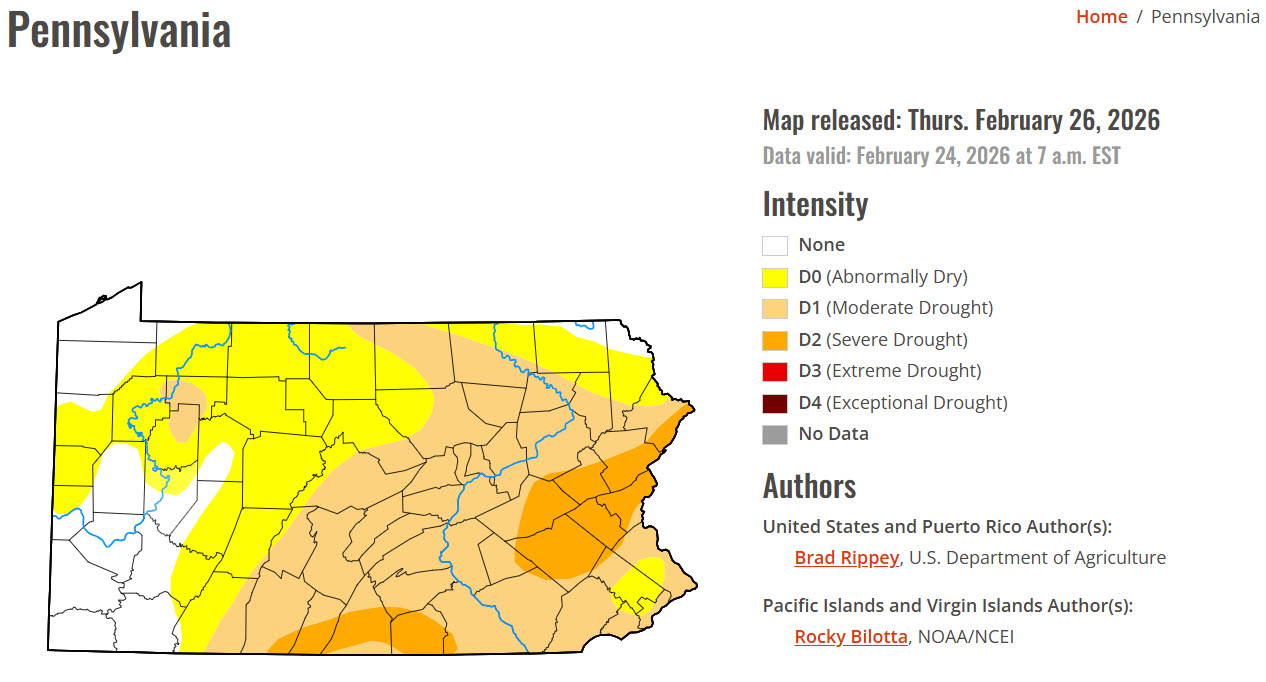
Most of Centre County has been experiencing moderate drought conditions as of February 24.