Summary of the 2025 Atlantic Hurricane Season

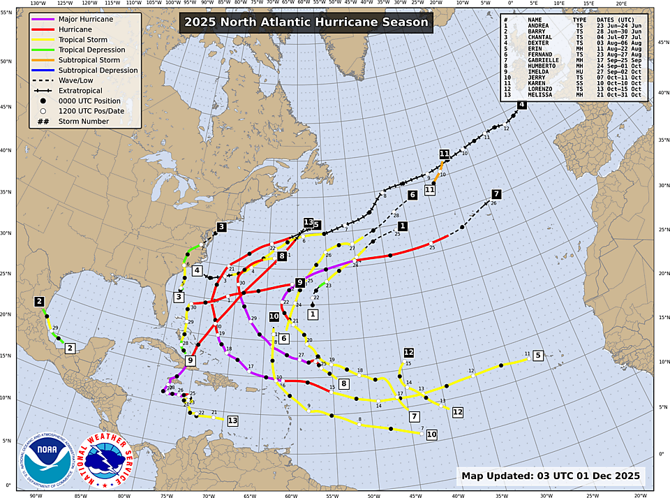
The 2025 Atlantic hurricane season has ended. There were 13 named storms, 5 hurricanes, and 4 major hurricanes (>= 3 on the Saffir-Simpson Scale). There were no U.S. hurricane landfalls, and no hurricanes in The Gulf of America.

2025 Atlantic Hurricane Summary Table

TypeNameDatesMaximum Wind (knots)
Tropical StormAndrea23-24 June35
Tropical StormBarry28-30 June40
Tropical StormChantal4-7 July50
Tropical StormDexter3-6 August50
Major HurricaneErin11-22 August140
Tropical StormFernand23-27 Aug50
Major HurricaneGabrielle17-25 September120
Major HurricaneHumberto24 Sep-1 Oct140
HurricaneImelda27 Sep-2 Oct85
Tropical StormJerry7-11 October55
Subtropical StormKaren10 October40
Tropical StormLorenzo13-15 October50
Major HurricaneMelissa21-31 October160

Summary of the 2024 Atlantic Hurricane Season

The 2024 season ended yesterday. There were 18 named storms, 11 hurricanes, and 5 major hurricanes (>= 3 on the Saffir-Simpson Scale).

Michael Mann hilariously predicted 33 named storms.

2024 Atlantic Hurricane Summary Table

Name       Dates     Max Wind (mph)

TS Alberto 19-20 Jun         50
MH Beryl   28 Jun-9 Jul    165
TS Chris   30 Jun-1 Jul     45
H Debby    3-9 Aug           80
H Ernesto  12-20 Aug     100
H Francine 9-12 Sep         100
TS Gordon  11-17 Sep        45
MH Helene  24-27 Sep     140
H Isaac    26-30 Sep         105
TS Joyce   27 Sep-1 Oct    50
MH Kirk    29 Sep-7 Oct   145
H Leslie   2-12 Oct          105
MH Milton  5-10 Oct       180
TS Nadine  19-20 Oct        60
H Oscar    19-22 Oct        85
TS Patty   2-4 NOV           65
MH Rafael  4-10 Nov       120
TS Sara    14-18 Nov         50

2021 Atlantic Hurricane Season

The 2021 Atlantic hurricane season has officially ended. Although all of the official names were used, four of those storms were short-lived or extratropical, and, in my humble opinion, should not have been named (Ana, Odette, Teresa, Wanda). There were officially 21 named storms, but there were really just 17. There were 7 hurricanes of which 4 were major. One of those, Ida, made landfall in the U.S. None of the storms exceeded Category 4. Ida and Sam were the strongest this year at Category 4. The Accumulated Cyclone Energy (ACE) for the season was lower than 2020.

Harvey and Irma Are Not A Sign of Climate Change

at201711_sat Sorry climate alarmists, but you can not blame this year’s major hurricanes on climate change, global warming or whatever you want to call it.

Posting on the Watts Up With That blog.

Prior to this season, there haven’t been any major hurricane landfalls in The United States since Wilma in 2005. This season is simply an anomaly. In fact, the frequency of major hurricanes has been decreasing.


Tropical Storm Matthew

Tropical Storm Matthew formed today. It is forecast to become a hurricane this Friday.

matthew1

What is unusual is that the forecast track has the system making a hard right turn to the north sometime this weekend. Most of the models are in agreement to that forecast.

matthew2

However, the two main models, GFS and ECMWF, disagree on where it will track a week from now. An earlier run of the GFS had it going up Chesapeake Bay next Thursday. The ECMWF has it moving slower with a possible landfall in southern Florida, so this should be watched carefully in the coming days.

Gaston and Invest 99L

Tropical Storm Gaston developed today. However, unless you’re shipping something across the Atlantic, that’s all you need to know. It is forecast to recurve and remain at sea.

two_atl_2d0

The focus is still on Invest 99L. Now the ECMWF model is bullish on possible US landfall in The Gulf of Mexico around the Florida panhandle next Tuesday. The GFS model, not so much. Still too far out for any reasonable certainty.

storm_99

Invest 90 and 99

As stated in a previous post, the forecasts can significantly change for systems that are forecast many days in advance. The 06 UTC GFS model run is not so bullish on Invest 99. The GFS now shows the storm making a hard right out to sea as it moves near The Bahamas.

storm_99

Focus is also on Invest 90 which is ow developing off the west coast of Africa. The models, as of this writing, indicate that it will not be a threat to the US.

storm_90

Proto Gaston

The following image looks innocuous, but it has the potential to develop into a major Atlantic tropical system within the next week or so.

99L

The models, as of this afternoon, have the storm tracking near Florida and/or into The Gulf of Mexico. However, this is still many days away and the forecast can change.

storm_99

The GFS model is especially bullish, as seen in the video below.